This article was updated April 17 to correct the name of the satellite, which is known as Carboite-2 and VividX2
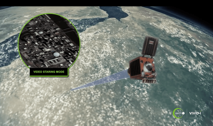
COLORADO SPRINGS — British startup Earth-i unveiled the first color video captured by its VividX2 satellite, a prototype for its future Earth imagery constellation, April 16 at the 34th Space Symposium here.
The videos show cars in Nashville, Tennessee, airports in Dubai, United Arab Emirates, and Buenos Aires, Argentina, and city life in New Orleans, Louisiana, San Diego, California, and Sydney, Australia.
In January, Earth-i launched VividX2, a 100-kilogram satellite built by Surrey Satellite Technologies Ltd. (SSTL) and also known as Carbonite-2, aboard an Indian Polar Satellite Launch Vehicle into sun synchronous orbit.
“We are really delighted with the quality of imagery we are getting even at this early stage of commissioning,” Richard Blain, Earth-i chief executive, told SpaceNews. “It is exceeding our expectations.”
Earth-i anticipates wide and varied commercial and government demand for its imagery because its satellites are equipped with ultra-high-definition color cameras capable of capturing up to 50 frames per second.
“The extra contextual information that comes from video is helping us derive understanding of what we are seeing in the images,” Blain said. “Data from space is informed by weaving in additional data sources. One of the ways we look at that is time and movement information are a couple of golden threads that we can attach to our geolocated, time-stamped data.”
Earth-i imagery could be used, for example to observe a wind turbine farm and determine which turbines are turning and how quickly. With that information, “we can calculate power outputs,” Blain said.
In addition, Earth-I can use its imagery to produce detailed 3D models.
“As we fly over a target and stare at it for up to two minutes from a whole series of different angles, we collect information that allows us to build more detailed 3D models than you could do with the same satellite using stereoscopic imagery,” Blain said.
Commercial customers are interested in using Earth-i imagery to monitor traffic, enhance border security and keep tabs on activity at ports, Blain said. In addition, “We can see in detail an area of approximately 25 square kilometers of a city or large town and look at the patterns of life for up to two minutes,” he added.
Earth-i also plans to offer customers high-resolution images it creates by compiling the data from a series of images.
“We collect up to 50 frames per second of an object,” Blain said. “In half a second, that’s 25 pictures of the same object, but there are tiny differences because the satellite is moving and Earth is moving. By stacking those images together, we can increase effective resolution down to around 60 centimeters or so.”
SSTL owns and operates Carbonite-2, which supplies data to various customers including the U.K.’s Royal Air Force, Joelle Sykes, SSTL spokeswoman said by email.
Currently, SSTL is building the first five satellites for Earth-i’s operational constellation. Those satellites will be delivered to Earth-i in late 2019.
“We are hoping for launch in late 2019 or early 2020,” Blain said. “We have an option with a particular launch provider. I can’t say who it is.”
Earth-i plans to offer at least three daily revisits for any location on Earth when it completes its 15-satellite constellation.
“We contract with SSTL such that they build batches of five satellites,” Blain said. “We will build at a cadence that matches the demand.”
With each batch of new satellites, Earth-i plans to update its technology. For example, the company will look at bolstering onboard processing and communications systems to allow satellites to sift data and download it more rapidly, Blain said.
Blain declined to discuss the cost of Earth-i’s constellation or its financing other than to say the firm relies on Houlihan Lokey, a Los Angeles-based investment bank.
“We are a well-funded, confident company with a very clear financial roadmap and a very carefully designed and executed business plan,” Blain said.
Earth-i is not the first company to offer video imagery from space. Skybox Imaging, a company later renamed Terra Bella and purchased by Planet, captured black and white imagery in 2013 with a high-resolution video camera on its SkySat-1 satellite.
Canada’s Urthecast began releasing color video imagery from a camera mounted on the International Space Station in 2015.
Related
ncG1vNJzZmiroJawprrEsKpnm5%2BifKat0a2fZqFdqru3scilqmaemafAtXnCqKOoql2rtqWxzmaamqikqr%2BmsIybsGahpKh6t7XVopuxal2orrWxy6WgrZ1f